
#1295 Too Né
from 2018 by Listening to America with Clay Jenkinson

-
Streaming + DownloadIncludes high-quality download in MP3, FLAC and more. Paying supporters also get unlimited streaming via the free Bandcamp app.Purchasable with gift card
name your price
-
Buy the Full Digital Album
-
1776 Club
Join now to receive all the new shows Listening to America with Clay Jenkinson creates, including 19 back-catalog releases, delivered instantly to you via the Bandcamp app for iOS and Android. You’ll also get access to supporter-only exclusives. Learn more.Join Now $5 USD/month or more
about
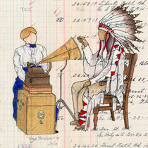
Coming up this week on the Thomas Jefferson Hour, we talk about a long lost, recently discovered map that dates back to Lewis & Clark. Jefferson sent Meriwether Lewis up the Missouri River in 1804. They met a man named Too Né among the Arikara on the North Dakota, South Dakota border. Too Né later went to Washington to meet Jefferson and he made a map that is a beautiful rendition of the world, and it was lost for more than 200 years, recently discovered in the Bibliothèque nationale de France. We talk a bit about how Native Americans looked at things, and how the maps from their time and our time obviously differ. Native American maps have a fundamentally different way of seeing than our maps, and once you learn how to do it, all this sacred and other information pops out. Clark was listening to Too Né and has some of that data in his famous journal. So join us for all that and more on this week's Thomas Jefferson Hour.
---
DS: 00:04 Good day, Thomas Jefferson Hour podcast listeners, good day citizens, and thank you for listening this week. Oh, one of my favorite subjects, a archaeology, history. We talk about Too Né and the map discovered in France.
CSJ: 00:19 When you think about the Indian peoples that Lewis & Clark met, you think of the Shoshone and the Mandan and the Lakota and the Clatsop. You don't normally put the Arikara high on your list. They deserve a much higher place on anyone's list than they have had. And this fellow from the University of New Mexico, a man named Dr Christopher Steinke, discovered in the Institut nationale de France, a map that this man Too Né, the Arikara who traveled with Lewis & Clark for a time, drew for them that actually has an image of the keel boat on it, has stick figures of Lewis & of Clark. He drew a map for them, took that map to Washington DC. He died in Washington DC, unfortunately was buried there. That map has disappeared for more than 200 years, David, and it was recently rediscovered and I devoted this whole May issue of We Proceeded On, the official journal of the Lewis & Clark world, which people can subscribe to by going to the Great Falls site. I devoted the whole issue to this extraordinary map and I knew the minute I started working on this that you would find it fascinating.
DS: 01:25 Oh. And I did. I really did. And really that's what we talk about this week, and you can find out more about We Proceeded On, the Lewis & Clark Trail Heritage Foundation, and how to join so you can get copies of We Proceeded On, if you go to jeffersonhour.com and there's also a pretty high resolution copy of Too Né's map that you can see at that website. And while you're there I'll keep it real — I won't even do the voice — you can support the Thomas Jefferson Hour, we really appreciate it — all support goes directly to the show and without it we are nothing.
CSJ: 02:04 So David, what — people maybe don't know this, but I knew you in the Lewis & Clark context way before I knew you, right, in the Jefferson context, and I was doing a big 13 hour, 13 part radio documentary —
DS: 02:04 I still have a copy of that —
CSJ: 02:22 I came here to do some of the work and I contacted you, I had heard of you and I knew of your great work with Native American music and culture and I said, would you be willing to provide some studio time and so on. And I interviewed Dayton Duncan in this very space and that was a great day.
DS: 02:22 What a great guy.
CSJ: 02:46 But you, then, provided music for Ken Burns' film.
DS: 02:49 Some of it, yes. Not all of it.
CSJ: 02:50 And you showed me — one of the greatest moments of my entire life was when you showed me that there is a living, faithful, Hidatsa oral tradition of song that can be dated back to Sacagawea.
DS: 03:07 Yeah. Yeah. That — Well, that was a pretty interesting discovery for me too.
CSJ: 03:11 That you were working with a young Native American woman who was singing. She was singing like pop songs and crossover songs, you said, do you have any like traditional songs? And she sang one and because of your work with a woman named Frances Densmore who was an ethnomusicologist who came out to the great plains —
DS: 03:27 Careful, we're really going to have a long intro —
CSJ: 03:29 But I can give you the short answer to it, that you recognized that this young woman's 20th century, early 21st century song was a not very different rendition of a song dated back to Frances Densmore at the beginning of the 20th century.
DS: 03:29 Pretty spot on.
CSJ: 03:48 She was recording on cylinder discs, and you would and you just gotten — you've just gotten praise for having remastered some of those cylinder discs and gotten them to the right speed. They were being played at the wrong speed for decades.
DS: 03:48 That's a long story, too.
CSJ: 04:01 All I'm saying is that I knew you in Lewis & Clark world long before I knew you in Jefferson, before you became the semi permanent guest host of the Thomas Jefferson Hour, and you've won awards for that work
DS: 04:01 Oh stop.
CSJ: 04:12 And now this map. Here's my goal, I want to get Russ Eagle out here, you know Ross?
DS: 04:12 Oh Great. Yeah.
CSJ: 04:18 And we're going to rent a pontoon and start at Mobridge, South Dakota and go up the river along the Too Né route.
DS: 04:18 Nice.
CSJ: 04:30 To see Jupiter's house and to see the Medicine Rock and to see the ancient ruins of the Mandan villages and all the things that Too Né tells to Clark. You've never seen them from the river. I've never seen them from the river. The river is now a lake. That's part of it, but I want to take that journey with maps, journals, Too Né's map, and follow that for two or three days and photograph the living daylights out of it.
DS: 04:57 Boy, that would be fun.
CSJ: 04:57 Wouldn't that be something?
DS: 04:57 It really would.
CSJ: 04:57 And you could bring the drone.
DS: 05:01 Yeah. And you know, if there's anybody who's really interested in this Densmore audio connection, maybe we —
CSJ: 05:01 They will help us —
DS: 05:11 That would be a fun thing to talk on the Jefferson Hour. Unless it's a little too far out of range —
CSJ: 05:19 It's not out of range, because as you know, we talked in this show about Jefferson's instructions and if he could have said, 'oh, and take a cylinder disk, and record Native American sounds,' of course he would have done that. The technology didn't exist.
DS: 05:31 So let's go to the show. So this week we're talking about Too Né and the maps and a number of things.
CSJ: 05:31 Subscribe to We Proceeded On.
DS: 05:40 Go to jeffersonhour.com if you can't find it and we'll have links there. And once again, thank you for listening.
CSJ: 05:50 Good day citizens. And welcome to the Thomas Jefferson Hour, your weekly conversation. Well this week it's with the of the Thomas Jefferson Hour, the man who portrays Jefferson when he's here. Mr Clay Jenkinson. Good day to you sir.
CSJ: 05:50 Good day to you David.
DS: 06:06 And as I would always start with a pleasantry with Mr Jefferson, I shall start the same with you, sir. How's your garden doing?
CSJ: 06:13 Well it is planted, that's for sure. And that was the last — the latest planting that I can remember. I finally got it finished around the fifth of June, 2018 in North Dakota where we live. You really don't dare plant your tomatoes before Memorial Day.
DS: 06:13 No profit in it.
CSJ: 06:13 Because they often freeze —
DS: 06:13 Or stunt.
CSJ: 06:35 And so I waited and we've had really an unusual spring and I've been traveling and busy and so I finally got out there and now I have two gardens, my large vegetable garden, which has 50 tomato plants and six rows of sweet corn.
DS: 06:35 Oh, you show-off.
CSJ: 06:49 And onions and beans and peas and cucumbers.
DS: 06:54 We need to get some photos like we have in previous years.
CSJ: 06:54 It'd be good. Bring the drone.
DS: 06:54 Yeah, happily.
CSJ: 06:58 And then the other garden, the Jefferson Garden is the raised garden. And in it with the help of our friend Pat Brodowski of Monticello, the head gardener there, I have planted mostly Jefferson seeds. And then I planted what are called three sisters. You know what that is. Three sisters are Native American combinations in one hill of beans, sometimes squash, sometimes corn, but three plants and the corn stock then becomes the prop and the beans then grow around it and so on and so forth. And this was the sacred way, or at least the very deeply established way of planting amongst the Mandan Hidatsa. So I always do that. So it's all planted now. And then I, it's been dry as you know. And so I got out four sprinklers and I've — this year I've tried to place them where they will get to every corner of the garden and there's always one beleaguered corner that doesn't quite get enough, but it'll cost a fortune, I think, this summer. I don't think we're going to have enough —
DS: 08:00 All that matters is that you can go out there in the shank of the evening and sit and look and enjoy as Jefferson I'm sure did.
CSJ: 08:08 Well, you know, I do it for two reasons. I do it because of Thomas Jefferson and I do it because of my grandmother Rhoda Strauss of Fergus Falls, Minnesota.
DS: 08:15 And you do it because you like to eat.
CSJ: 08:17 And then I can, I can the living daylights. I still have about 150 jars of tomato sauce from last year.
DS: 08:17 Oh my.
CSJ: 08:17 We'll see what happens.
DS: 08:17 I called this program this week — I asked if we could revisit something that we touched on in an earlier show, and that is the Too Né map, and it — since we discussed this the first time, you have given me a copy of We Proceeded On, which is the publication of the Lewis & Clark Trail Heritage Foundation
CSJ: 08:48 People can subscribe by going to the Heritage Foundation's website in Great Falls, Montana, and for a small fee you get all four — you become a member, and you get all four issues of this journal, We Proceeded On.
DS: 09:01 And of course we will put a link if there's not already one there on our website. I believe the map has been posted there because we've had a number of interesting inquiries about the map. In fact, I think you just got a letter last week from someone who was very excited about it. We talked about that.
CSJ: 09:01 Well, it is exciting.
DS: 09:01 It's astounding.
CSJ: 09:21 I've been doing a little media based upon it because it's a discovery. So let me quickly set the stage.
DS: 09:21 Right.
CSJ: 09:28 Lewis & Clark traveled through the Missouri country and the Columbia River country between 1804 and 1806, and they brought back this extraordinary map that was published in 1814, Clark's map. It's really one of the masterpieces of American cartography, but we like to think of them as having traveled into this completely unknown country without any ideas because they were explorers — that isn't true at all, David, they were really working from previous knowledge of other white traders and explorers, at least up to today's North Dakota and then west of today's North Dakota, Native Americans were drawing maps for them on the ground, putting little piles to show mountains and using sticks to show rivers and tributaries and so on. And so when Lewis & Clark left, Fort Mandan, Lewis says, we're now about to penetrate a country at least 2000 miles in width upon which the foot of civilized man has never walked. But the fact is they already had a pretty good sense from the Native peoples, who were their hosts, of what they should expect to find. And so most of those maps that were written in snow or written on skins of animals or written in the dirt, naturally have disappeared forever. A few of the maps have survived and one of them, maybe the best of all the maps, has been languishing in a French archive for more than 200 years in the Bibliothèque nationale de France in Paris. And it was discovered by a researcher at the University of New Mexico by the name of Dr Chris Steinke. And he wrote an article about it in William and Mary quarterly in 2014. A friend of mine in Montana brought it to my attention.
DS: 09:28 And then you interviewed Mr Steinke for this issue of WPO.
CSJ: 11:16 That's correct. I thought of reproducing his essay, but I thought, well, it's already — that's already been published. I can turn people to it. But I — then I interviewed him and I got the two great cartographers in the Lewis & Clark world, a man named Herman Viola of the Library of Congress and John Logan Allen, formerly of Yale, but most recently the University of Wyoming in Laramie. I got them to assess the map. They wouldn't, David, they wouldn't assess it. Neither of them knew about it. They wouldn't assess it unless I sent them extremely high quality laminated versions of the map. And so I had to go to a — get a high resolution and take it to a laminator. I sent them to them and then they wrote back into and basically just said, wow.
DS: 11:57 Well — and that's one of, you know, if I can let my own excitement come out about this. One of the things that really floored me about this is that it, here it is a couple hundred years later, more than, and we're still finding very important artifacts connected to Lewis & Clark. And it makes me wonder, you know, what else is out there.
CSJ: 12:21 You are correct sir. So a man named Harry Fritz, who's an emeritus professor of history at the University of Montana in Missoula, an old friend of mine — friend of a teacher of, of Stephanie Ambrose Tubbs, the daughter of the great late Stephen Ambrose. He said during the bicentennial, 'well we basically know everything we're ever going to know about this story, how many times are we going to kick around the same can.' Well he was wrong, and so this map is one of the discoveries. Also James Holmberg of the Filson Club down in Louisville was part of the discovery of 50 some letters by William Clark that were in the attic in Louisville and they were discovered and he published them in, I think in 1989. There are probably — while we know Robert Frazier kept a journal — it could still be out there. Lewis maybe could have kept journals that we don't have yet. I mean, things get lost and so maybe we'll find more.
DS: 13:13 There are sites, historical sites — you and I have spent a great deal of time talking about the, where the actual site of Fort Mandan is in North Dakota and nobody really knows.
CSJ: 13:13 I know someone who knows.
DS: 13:25 The thought is that it was completely destroyed by the river changing course.
CSJ: 13:25 Maybe. Maybe not.
DS: 13:34 I think, you know, you look at what's going on archaeologically and the use of satellites to find unusual depressions and they've discovered, you know, Viking villages and things like that. So who knows what's going to come up in the next five or 10 years. And that's one of the reasons after reading this issue of We Proceeded On, I got so excited about it.
CSJ: 13:55 Well, it's very important. So let me just say this map is a very, very significant discovery and all hail to Dr Christopher Steinke for doing it and publishing the pioneering article in the October 2014 issue of William and Mary quarterly.
DS: 14:12 He's still looking for things in Europe, isn't he?
CSJ: 14:15 Yes. And others too. And so there are plenty of people doing this but, but as I say, things get mislabeled or they're — the labels are so vague that you can't really know what you're looking at. What I am amazed at — he was not a Lewis & Clark guy. He's now at the University of Nebraska Kearney state. He was looking at Native American cartography, so maps by Native peoples indigenous maps. And he happened upon this and he was shrewd enough, well enough trained in history that he realized, oh, this is the Lewis & Clark map, and here's the story. Lewis & Clark got to the Arikara villages in northern South Dakota along the mouth of the Grand River. And they came there about October 8th, 1804. And while they were there, they met a leader of the Arikara, whose name is Too Né, or Ar-ke-tar-na-Shar, or Piaheto, but let's say Too Né for the purposes of today. And he was a highly intelligent man who then accompanied them from the Grand River all the way up to what became Fort Mandan. So he traveled with them for about three weeks. And then he stayed on diplomatic mission amongst the Mandan, and Hidatsa, was trying to work out a reconciliation between the Arikara and the Mandan. And then Lewis & Clark said, well, would you be willing to go to Washington DC to meet the great father? Jefferson had instructed Lewis to try to convince Native leaders to come to Washington to meet him. And so they convinced Too Né to make the long journey from northern South Dakota to Washington DC. He went with an interpreter by the name of Joseph Gravelines, who plays an important part in the story. He met Jefferson and then unfortunately, Too Né died in Washington DC on April 6th, 1806. So now this emissary from the Arikara has gone off to meet the great father and died. So Jefferson writes a famous letter of condolence and sends it back up the river with Joseph Gravelines to the Arikara. And so, but, the point of all this is that while Too Né was in the presence of Joseph Gravelines and others in St Louis and eventually Jefferson, he produced a map and that map is the one that was discovered and it's filled with extraordinary, fascinating material about how the Arikara saw North America.
DS: 16:48 I want to talk to you more about Joseph Gravelines later in the conversation. I don't know a lot about him and I learned so much reading this issue of We Proceeded On, and his relationship with Toussaint Charbonneau, or I guess, the timing about Toussaint Charbonneau sort of became an unhappy employee.
CSJ: 17:07 So for those that don't know, Charbonneau was the husband of Sacagawea. Lewis & Clark hired him and they were going to go to the Rocky Mountains, but Charbonneau was kind of a rascal and he went on strike and Lewis & Clark said, well, the heck with it, we're, we'll take somebody else. And they almost took this Joseph Gravelines as their interpreter. If they had, we wouldn't know who Sacagawea is.
DS: 17:25 This is the time of year when I'm always interested to revisit Lewis & Clark and all aspects of it. And thanks to this article, we have some new grist for the mill.
CSJ: 17:36 The important thing David, is that this is a significant discovery in Lewis & Clark Studies. It is not true that there's nothing more to say, and it has particular importance for North Dakota because the map — it includes everything from Santa Fe to today's Winnipeg, but the map really centers on the land between the South Dakota border and old Fort Mandan, and it really opens a whole new world in one of the parts of the Missouri River Basin that are not that well known.
DS: 18:05 I have many more questions if you will entertain that, sir.
CSJ: 18:05 Course.
DS: 18:09 We're going to take a short break, but we'll be back in just a moment. You're listening to the Thomas Jefferson Hour.
DS: 18:19 Welcome back to the Thomas Jefferson Hour. Your weekly conversation with or about President Thomas Jefferson. This week we're speaking with the creator of the Thomas Jefferson Hour, Mr Clay Jenkinson. And we're talking specifically about Lewis & Clark and Too Né, and this wonderful discovery of a map in France.
CSJ: 18:39 I take no credit for the discovery of the map. That was this Dr Christopher Steinke, at the university of New Mexico, now at the University of Nebraska at Kearney state. But my friend Kevin O'Bryant out in Mi
lyrics
"Too Né's data wound up in the journals and all of it is on the map, and the map deepens the journals, and the journals deepen the map."
— Clay S. Jenkinson
This week on the Thomas Jefferson Hour, we feature an extended conversation about the recently discovered map from the Lewis and Clark Expedition drawn by an Indigenous guide named Too Né. The map was found in the Bibliothèque nationale de France, and it's the subject of an entire issue of the Lewis and Clark Trail Heritage Foundation’s journal, We Proceeded On.
credits
license
all rights reserved
tags
about

Listening to America with Clay Jenkinson
The Thomas Jefferson Hour is a weekly radio program dedicated to the search for truth in the tradition of Thomas
Jefferson.
Nationally acclaimed humanities scholar and award-winning first-person interpreter of Thomas Jefferson, Clay S. Jenkinson, portrays Jefferson on the program, and he answers listener questions while in the persona of our third president.
... more


contact / help
Listening to America with Clay Jenkinson recommends:
-
Lakota Songs
by Densmore Repatriation ProjectIn episode #1511, Clay interviewed David about The Densmore Repatriation Project and David's work to restore Frances Densmore's wax cylinder recordings.
go to album -
Talking out of Tights
by Clay S. JenkinsonI hope you will find these stories uplifting as well as funny. I’m a Jeffersonian. I believe we are all on a quest to become our best selves.
go to album -
Becoming Jefferson's People
by Clay S. JenkinsonBecoming Jefferson’s People is part manifesto, part call for a new political persuasion, part self-help book, and part critique of the consumerist world empire that the United States has become.
go to album
If you like Listening to America with Clay Jenkinson, you may also like:
-

Shapes in Twilights of Infinity
by ESINAMfeatured on Bandcamp Radio Nov 9, 2021
go to album -
Cycle 1: DATABODY
by BELLWETHERA four episode story cycle about collisions with technology from this L.A. artist.
go to album -
all of god's money / a tribute to wilco's yankee hotel foxtrot
by Better YetMikey Erg, Meat Wave, Ratboys, Adult Mom and more cover Wilco on this collaborative release benefiting AIDS Foundation of Chicago.
go to album